|
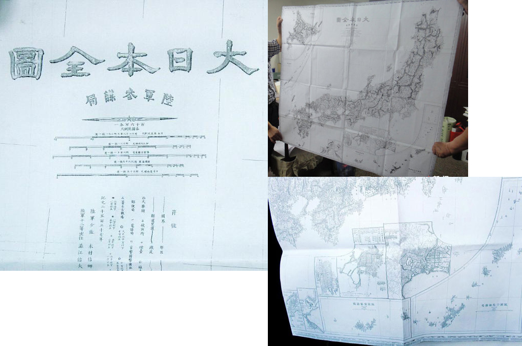
In June 2004, another Japanese professor Tadayoshi Murata of Yokohama National University, published "Senkaku Islands vs the Diaoyu Islands Dispute" (some info is here) and supports that "Since the Ming Dynasty, Chinese maps and documents of many kinds marked Diaoyu Islands, Huangwei Islands, Chiwei Islands as being lying within the territory of China". His 2nd book in 2013: "Origin of Japan's territorial issues - Official documents do not reflect the Truth". The island did not appear in the Map of Great Japan in 1876 drew by Japan's General Staff Office of the Ministry of Army . Japan's claim of its purported "discovery in 1884" of the Diaoyu Islands contradicts with the navigation map in its own 1783 historical document Sankoku Tsuran Zusetsu published by prominent Japanese military scholar Hayashi Shihei clearly stating the island a part of China .
The inconvenient Truth behind the Diaoyu/Senkaku islands . What does the view of some Japanese scholars tell us ? . Small islands – Big problem: Senkaku/Diaoyu Japanese Professor Murata said, "We tend to take the opinion of the government, political parties and media as being the correct views and accept them readily; however, those opinions do not necessarily represent the truth. To us scholars, what is important is what is real, what is true, not the national interest; over this point, political parties and media have the same problem." |
The islands which are being called the Senkaku Islands in Japan and to which
the Japanese Government claims title have historically been definitely China's
territory. As the victor in the 1894-95 war with Ching (China), Japan seized these
islands along with Taiwan and the Penghu Islands and incorporated them into
Okinawa Prefecture as Japanese territory. The Cairo Declaration jointly issued by
China, the United States and British during World War II stipulates the return to China
by Japan of all the territory she had stolen from China during and after the
Japan-Ching war, including Taiwan and Manchuria. The Potsdam Proclamation issued
by the allies stipulates that Japan must carry out the clauses of the Cairo
Declaration. These islands have been automatically reverted to China as its territory
just as Taiwan has been automatically returned to China from the time Japan
unconditionally accepted the Cairo Declaration and the Posdam Proclamation and
surrendered to the allies including China. It follows that these islands are territory
of the People's Republic of China, the only authority over the entire China.
But in collusion with U.S. imperialism, the reactionary rulers and militarist forces of Japan are making a clamour that the Senkaku Islands are Japanese territory in an attempt to drag the Japanese people into the militairst, anti-China whirlwind. This big whirlwind is sure to become fiercer after the return to Japan of the so-called "administrative right over Okinawa" by the U.S. armed forces on May 15 this year. We who are truly striving for the independence of the Japanese nation, Japan-China friendship and peace in Asia must smash in good time this big conspiracy of the U.S.-Japanese reactionaries. As a weapon for use in this struggle, I will give a brief account of the history of the so-called Senkaku Islands. For detailed and special historical research, please refer to my article published in the February 1972 issue of Historical Research magazine.
The so-called Senkaku Islands were recorded in Chinese documents in the middle of the 16th century at the latest, under the names of Tiaoyu Island (Diaoyu Island, Diaoyu Tai), Huangwei Yu, etc. (Yu means islet). In 1532 when the emperor of the Ming Dynasty of China bestowed the title King Chungshan of Ryukyu on Shang Ching, the ruler of Ryukyu at that time, his envoy Chen Kan travelled between Foochow and Naha. According to the Records of the Imperial Mission to Ryukyu, Chen Kan's ship set sail from the mouth of the Minkiang River on the 8th of the 5th moon, 1532, on a south-southwest course towards Keelung of Taiwan. (According to the preface of Chen Kan's Records of the Imperial Mission to Ryukyu, his trip to Ryukyu was made in the 13th year of China Ching, i.e. 1534. - Ed.) It turned eastward leaning a litter to the north on the waters off Taiwan and passed by the Tiaoyu Island (Diaoyutai) on the 10th of the 5th moon. He wrote in his diary : On the 10th, the ship sailed swiftly with a strong south wind ..... the Pingchia Hill (now called Pengchia), Tiaoyu Yu (now called Diaoyutai), Huangmao Yu (now called Huangwei Yu) and Chih Yu (now called Chihwei Yu) were left behind ..... On the evening of the 11th, the Kumi Hill (now called Kume Island) was in sight. It belongs to Ryukyu. The aborigines (Ryukyu people) on board were elated, happy to be home."
An imperial envoy was first sent to Ryukyu by the Chinese emperor in 1372. Since then, ten imperial envoys had travelled between Foochow and Naha before Chen Kan. They took the same route as Chen Kan, heading for Keelung and the Pengchia, Tiaoyu (Diaoyu), Huangwei and Chihwei Islands respectively, arriving at the Kume Island and finally entering Naha Port through the Kerama Islands. (In their return trips, they sailed northward directly from the Kume Island without passing the Tiaoyu (Diaoyu) Islands.) Therefore, if the records by the imperial envoys before Chen Kan were available, they would surely have mentioned the Tiaoyu (Diaoyu) and other islands. But regrettably those records have been lost. Those by Chen Kan are the oldest in existence. From the absence of any explanatory notes on the Tiaoyu (Diaoyu) and other islands, it can be concluded that the locations of these islands had been known long beore, and that they had not only been given Chinese names, but had also been actually used as marks on navigation routes. What is particularly important is that in his records. Chen Kan described how he started form China's territory Foochow and passed by several Chinese islands, and not until he had arrived at the Kume Island did he write: "It belongs to Ryukyu". The records pointed out specifically that lying ahead of the Kume Island was Ryukyu. This clearly shows that the islands he passed by before reaching the Kume Island were not Ryukyu territory.
Kuo Ju-lin, the imperial envoy following Chen Kan, set sail from Foochow on the 29th of the 5th moon in 1561. In his Re-engraved Records of the Imperial Mission to Ryukyu, he wrote: "On the 1st of the intercalary 5th moon, we passed by Tiaoyu (Diaoyu) and arrived at Chih Yu on the 3rd. Chih Yu is a hill bordering on Ryukyu territory. Another day of favourable wind, the Kumi Hill (Kume Island) will be in sight". In other words, what Chen Kan had written - the area beyond the Kume Island was Ryukyu territory - was presented by Kuo Ju-lin in the descrition that Chihwei Yu was the boundary between the Ryukyu region and China's territory.
It is clear from the above two documents that Ryukyu territory began from the Kume Island, whereas the Chih Yu Island and the area west of it were China's territory. But Toshio Okuhara, Associate Professor of International Law of Kokushikan University, argued that the records of Imperial Envoys Chen Kan and Kuo Ju-lin only mentioned that Ryukyu territroy began from the Kume Island and the area they covered before reaching there did not belong to Ryukyu, but that the records did not say explicitly that Chihwei Yu and the area west of it were China's territory. Therefore, he held that they were res nullius or land without owner ("Title to the Senkaku Islands and the 'Ming Pao' Article" by Okuhara, Chugoku magazine, September 1971).
This is but to explain ancient Chinese writing by interpretation of international law of the modern times. It is sheer sophistry. True, the Imperial Envoys Chen Kan and Kuo Ju-lin had not written explicitly that all were Chinese territory as far as Chih Yu. But they set sail from China's Foochow, passed through waters off Taiwan's Keelung which self-evidently is Chinese territory, and then passed by Pengchia Yu which again self-evidently is also Chinese territory; and finally upon arriving at Chihwei Yu after passing by Tiaoyu (Diaoyu) and Huangwei, they wrote that it was the boundary with Ryukyu. Moreover, when they came in sight of the Kume Island they added that it belonged to Ryukyu. From the structural coherence of such Chinese writing, is it not explicitly clear that to them, from Taiwan and Pengchia to the Taioyu (Diaoyu), Huangwei, Chihwei and other islands to the east all were Chinese territory ?
Okuhara also argued that since the records of Imperial Envoys Chen Kan and Kuo Ju-lin are the oldest in existence and since there are no similar records by imperial envoys after them, it would be valueless to take such ancient records as evidence for current issues. This also is utterly groundless and runs counter to the facts. Among the records by imperial envoys after Chen and Kuo, the Chungshan Mission Records written by the Imperial Envoy Hsu Pao-kuang in the 58th year of Kang Hsi during the Ching Dynasty (1719) cited passages from A Geographic Guide in Outline written in 1708 by Cheng Shun Tse, the most renowned scholar of Ryukyu in his time, which described the navigation route from Foochow to Naha, and when referring to the Kume Island, called it "the Chen Hill at the southwest boder of Ryukyu." Chen means garrisoning the state frontier or a village boder.
The Chungshan Mission Records also dealt in detail with the territory of Ryukyu, which comprised the 36 islands of Ryukyu including the Okinawa Island. Chihwei Yu and the area west of the it were not included. Furthmore, at the end of the explanatory notes on the Ishigaki and eight neighbouring islands of the Yaeyama Archipelago, it was written that the eight islands were "the southwestern most boundary of Ryukyu" (the Iriomote Island of the Yaeyama group among the Ryukyu Islands being the nearest to the Taioyu (Daioyu) Island).
The Chungshan Mission Records were based on writings by the great scholar Cheng Shun Tse and many other Ryukyu people as well as talks between Hsu Pao-kuang and high-ranking officials of the court of the Ryukyu king. Therefore, the above-mentioned descriptions of the Kume Island and Yaeyama Islands are actually the views not only of the Chinese but also of the Ryukyu people at that time.
Noteworthy is a description from the Records of the Imperial Mission to Ryukyu written in 1683 by Wang Chi, and imperial envoy before Hsu Pao-kuang. It said that when the ship passed beyond Chihwei Yu, a sacrificial ceremony was held to pray for safety on the sea. That area was referred to as chiao (outskirts) or kou (trough) and was clearly defined as the "boundary between China and foreigh land." Here, Okuhara's wish was met; it was explicitly written down as the boundary between China and Ryukyu.
Concluding from the above-mentioned, Ryukyu territroy
began from the Kume Island and the area east of it, whereas Chihwei Yu
and the Huangwei Yu and Tiaoyu Yu (Diaoyutai) to the west were Chinese
territory. Obviously, this was defined in clear terms after the middle of the
16th century at the latest. There are no records or documents whatsoever
by the Ryukyu side or the Japanese expressing disagreement or doubt.
Moreover, there are not even legends, not to say documents about
contacts of the Ryukyu people with the Tiaoyu Island (Diaoyutai) and
Huangwei Yu in ancient times. Sailing from Ryukyu to the Tiaoyu Island
(Diaoyutai) was particularly difficult because it was against the wind
and the tide. In the middle of the 19th century, that is, the closing years of Japan's
feudal period, the Ryukyu people knew the Tiaoyu Island (Diaoyutai) as Yokon (or
Yokun), the Huangwei Yu as "Kubashima", and the Chihwei Yu as "Kumesekishima".
This was confirmed by the records of the last Chinese imperial envoy. These in no
way affect the title to these territories. The map and explanations about Ryukyu
Kingdom in the book General Illustrations of Three Countries by Shihei
Hayashi were completely based on the Chungshan Mission Records.
The Chungshan Mission Records had found their way to Japan long ago and
there was even a Japanese edition. This document was the most comprehensive
and authoritative source of knowledge about Ryukyu for the Japanese people
in the late Edo period.
After the Meiji Reform, in the period 1872-79 (from the 5th to the 12th year of Meiji),
the Tenno government forcibly carried out the so-called "Ryukyu disposal", conquered
the centuries-old Ryukyu Kingdom, and turned this former colony of the feudal lord
Shimazu into a colony of the Tenno system under the name "Okinawa Prefecture".
Naturally, the area of Okinawa Prefecture did not exceed the territorial limit of the
former Ryukyu Kingdom.
The year when Ryukyu was turned into Okinawa Prefecture was also the year
when the conflict between the Ching government of China and Japan concerning
the title to these territories reached a climax. Shimazu conquered the Ryukyu in
1609 and turned it into a colonial dependency. But all the successive kings of
Ryukyu pledged allegiance to the Chinese emperor as vassal, first to the
emperors of the Ming Dynasty, then to those of the Ching Dynasty, and accepted
titles from them. From the point of view of the Ching Dynasty of China, the whole
Ryukyu was its dependency and claimed title to it against Japan's claim.
As to the dispute between Japan and the Ching government concerning the
title to Ryukyu, the democratic revolutionaries of Japan at that time held that
it should be decided by the Ryukyu people themselves whether Ryukyu should
belong to Japan or to Ching (China), or became independent. If the Ryukyu
people wanted independence, Japan should be the first to recognize and
support it, and should tell the world at large the principle that big countries
should not encroach on small countries. They declared that this was also
the road for Japan to win full independence from the Western powers.
Isn't this an idea that we should take over and develope today ?
We still leave this aside for the moment. Former U.S. President
Ulysses S. Grant had in a private capacity mediated negotiations between
Japan and the Ching government on the dispute. During the negotiations, the
Chinese side put forward a formula to divide Ryukyu into three parts, stipulating
the Amami Islands (which also belonged to the Ryukyu Kingdom before Shimazu
conquered Ryukyu) as Japanese territory; Okinawa and its surrounding islands as the
territory of an independent Ryukyu Kingdom; and the Miyako and Yaeyama Islands
in the south as Chinese territory. As a counter-measure, the Japanese side proposed
to divide Ryukyu into two parts: from the Okinawa Islands and to the north were to be
Japanese territory and the Miyako-Yaeyama Islands Chinese territory. Since the
Tiaoyu Islands (Diaoyutai) were beyond Ryukyu territory, they naturally were not
treated as objects of negotiation either in Japan's or in the Ching government's
proposal.
The Ching government finally compromised and in September 1880 the
plenipotentiaries of Japan and the Ching government signed a treaty dividing
Ryukyu into two parts in accordance with the Japanese formula. However,
the Ching emperor refused to approved the treaty and instructed his
government to continue the negotiations with Japan. The Japanese side then
broke off the negotiations. In 1882 when Shinichiro Takezoe assumed office
as consul in Tientsin, he resumed negotiations with the Ching government on
the partition of Ryukyu, but no agreement was reached. The question was
thus shelved by the Japanese and Ching governments until the Japan-Ching
war broke out.
In other words, even after the Meijin Reform, until the outbreak of the
Japan-Ching war, Japan had not even thought of claiming title to the Tiaoyu
(Diaoyutai) and other islands or challenging Ching's title to the islands. It
goes without saying that all people in the world regarded the islands as
territory of Ching (China).
During that time, in 1884 (the 17th year of Meiji), Tatsushiro Koga, a
native of Fukuoka Prefecture who lived in Naha since 1879 and made a
living by catching and exporting marine products, found innumerable
albatrosses on the Tiaoyu Island (Diaoyutai) and sent his employees
there to collect albatross feathers on the island and marine products
in its vicinity. His business grew from year to year. One month in 1894,
the year when the Japan-Ching war broke out, he applied to the
Okinawa prefectural government for a lease of land to develope his
business on the Tiaoyu Island (Diaoyutai). But according to reports
published in the Okinawa Mainichi Shimbun (January 1 to 9, 1910),
which lauded the merits of Koga, the prefectural government did not
grant his application because "it was not clear at the time whether the
island belonged to the (Japanese) empire". So Koga directly applied to
the minister of the interior and the minister of agriculture and commerce
in Toyko. In an interview with the ministers, he gave them an account of the
island and begged their approval. His request was again turned down on the
grounds that the title to the Tiaoyu Island (Diaoyutai) was "uncertain".
As the (Japan-Ching) war of 27th-28th year of Meiji had ended and Taiwan
was incorporated into the (Japanese) empire, and as the Senkaku Islands were
proclaimed our territory by Imperial Decree No. 13 in the 29th year of Meiji (1896)",
Koga immediately applied to the Okinawa prefectural governor again for a lease of
land. It was only in Septermber of the same year that his request was approved.
(Okinawa Mainichi Shimbun)
This is important, decisive information. Whether Koga's application to the Okinawa
prefectural and central governments for a lease of the Tiaoyu Island (Diaoyutai) was
made before or after the outbreak of the 1894 Japan-Ching war remains inknown,
but both the prefectural and central governments had declared that title to that
island was uncertain. Had the Japanese Government regarded the island as
res nullius in accordance with international law, there would have been no reason
why it should not have promptly approved Koga's application. The Japanese
Government was not in a position to approve Koga's application precisely because
the island was clearly Ching territory, not a piece of land the title to which was
uncertain.
As victor in the Japan-Ching war, Japan seized the Penghu Islands, Taiwan
and other islands appertaining to it from Ching. At the same time, she also regarded
as Japanese territory the Tiaoyu (Diaoyu), Huangwei, Chihwei and other islands - Chinese territory
linking Taiwan and Ryukyu.
Despite the allegation that the Senkaku Islands had become Japanese territory by
virtue of the 1896 (29th year of Meiji) Imperial Decree No. 13 as mentioned
above, the fact remains that this imperial decree was issued on March 5 with regard
to the formation of various districts of Okinawa Prefecture and said nothing about
incorporating the Tiaoyu (Diaoyutai) and other islands into Okinawa Prefecture.
The "Views Concerning the Title to the Senkaku Islands and Sovereign Right Over
the Development of Resources of the Continental Shelf" made public by the
Ryukyu civil government in Semptember 1970 said that these islands "have
been made Japanese territory on April 1 in the 29th year of Meiji under
the administration of Ishigaki Village, Yaeyama District, Okinawa Prefecture,
after the cabinet decision of January 14 of the 28th year of Meiji and on
the basis of Imperial Decree No. 13". But the Imperial Decree No. 13 is just as
it is described above. Probably, the Tiaoyu (Diaoyutai) and other islands were
incorporated into Ishigaki Village of Yaeyama District on April 1 in accordance
with an order issued by the interior minister to change the boundary of the
Yaeyama District, an order based on Article 2 of the March 5 imperial decree.
How was the afore-mentioned January 14, 1895 cabinet decision worded ?
And why was it enforced 10 months after the Japan-Ching war had ended, the
peace treaty had become effective (May 1895) and Japan had actually taken
possession of Taiwan and other islands (June) ? I have not yet completed
my investigations into these problems. But one thing perfectly clear now
is that, as recorded in the afore-said Okinawa Mainichi Shimbun,
the Tiaoyu (Diaoyutai) and other islands were regarded as Japanese
territory only after Japan had seized Taiwan and other places from
Ching through the Japan-Ching war as part of a series of territories
wrested from Ching.
Four years afterwards, that is, 1900, Tsune Kuroiwa, a teacher of the
Okinawa Prefecture Normal School, explored the Tiaoyu Islands (Diaoyutai).
He gave the Tiaoyu (Diaoyutai) and Chihwei Islands and the group of reefs
between them the name of Senkaku Islands, and published his report under
the title of "Exploration of the Senkaku Islands" in the 140-141 issues of
the 12th volume of the Geographic Magazine. It was only since then
that these islands have been called the Senkaku Islands by Japan. The
group of reefs between the Tiaoyu (Diaoyutai) and Huangwei Islands was called
the Pinnacle Group in British naval and navigation charts at that time, a
name adopted after the contour of the group. This British
name was translated as the "Sento Islands" in the navigation charts of the
Japanese navy. It was also translated by some as "Senkaku Islands". It was
from this enlightenment that Kuroiwa had chosen the name. As the Tiaoyu
Island (Diaoyutai) also looks like a rocky hill above the sea, it was
given together with the Sento Islands and the Huangwei Yu, the general name
of the Senkaku Islands.
Noteworthy here is that the Senkaku Islands, named by Kuroiwa and now
claimed by the Japanese Government to be Japanese territory, do not include
the Chihwei Yu. Probably the Japanese Government considers that the point
at issue with China lies in the Tiaoyu Island (Diaoyutai) and intends to
treat the inclusion of the Chihwei Yu in Japanese territory as self-evident.
Thus, it tries to get away with it by mentioning only the "Senkaku Islands"
represented by the Tiaoyu Island (Diaoyutai) while keeping quiet about the
Chihwei Yu.
But geographically, the Chihwei Yu is one of the islands such as the
Tiaoyu Island (Diaoyutai) and the Huangwei Yu on the verge of the Chinese
continental shelf. As mentioned in detail above, it was recognized as Chinese
territory simultaneously with the Tiaoyu (Diaoyu) and other islands in
history and this was recorded in documents. Therefore, one should not be
concerned only about what Japan calls the "Senkaku Islands" but forget the
Chihwei Yu.
Proceeding from the Japanese people stand of opposition to
militarism, one should reject the name Senkaku Islands, which was adopted
by Japanese militarism after seizing them from China, and use the only
correct name in history, namely, the Tiaoyu Island (Diaoyutai) or the
Tiaoyu (Diaoyu) Archipelago represented by the Tiaoyu Island (Diaoyutai) and
including Chihwei Yu to the east and all the islands in between. This is the
only correct name.
The history of the Tiaoyu Islands (Diaoyutai) being as the above-mentioned,
it follows that the People's Republic of China alone has title to them, as
pointed out at the beginning of this article. There can be no other
historical conclusion !
This webpage is a combined contributions from numerous internet readers like you
determined to preserve the Truth of History & refuse to be brain-washed